By Marisol Bo-oc, Helen Castano| 06:11 AM December 16, 2021

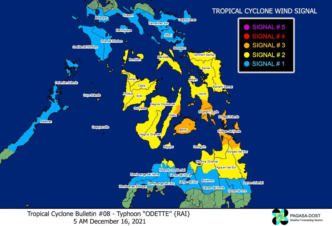
Tropical Cyclone Wind Signal No. 3 is now raised over Bohol as Typhoon Odette intensified further.
Under Signal No. 3 are Southern Leyte, the southern portion of Leyte (Abuyog, Mahaplag, City of Baybay, Inopacan, Hindang, Hilongos, Bato, Matalom, Javier), Bohol, and the eastern portion of Cebu (Lapu-Lapu City, Cordova, Carmen, Danao City, Compostela, Liloan, Consolacion, Mandaue City, Cebu City, City of Talisay, Minglanilla, City of Naga, San Fernando) including Camotes Islands, the Philippine Atmospheric Geophysical and Astronomical Services Administration (Pagasa) said in its 5 a.m. update on Thursday, Dec. 16, 2021.
As of 4 a. m., the center of the eye of Odette was estimated based on all available data including those from Hinatuan Doppler Weather Radar at 330 km East of Surigao City, Surigao del Norte.
It has a maximum sustained winds of 150 km/h near the center, gustiness of up to 185 km/h, and central pressure of 955 hPa.
TROPICAL CYCLONE WIND SIGNALS (TCWS) IN EFFECT
TCWS No.3 (Destructive typhoon-force winds prevailing or expected within 18 hours)
Visayas
Southern Leyte, the southern portion of Leyte (Abuyog, Mahaplag, City of Baybay, Inopacan, Hindang, Hilongos, Bato, Matalom, Javier), Bohol, and the eastern portion of Cebu (Lapu-Lapu City, Cordova, Carmen, Danao City, Compostela, Liloan, Consolacion, Mandaue City, Cebu City, City of Talisay, Minglanilla, City of Naga, San Fernando) including Camotes Islands
Mindanao
Dinagat Islands, Surigao del Norte, the northern portion of Agusan del Norte (Tubay, Santiago, Jabonga, Kitcharao), and the northern portion of Surigao del Sur (Carrascal, Cantilan, Madrid, Carmen, Lanuza, Cortes)
TCWS No.2 (Damaging gale- to storm-force winds prevailing or expected within 24 hours)

Luzon
Mainland Masbate, Ticao Island, Romblon, and Cuyo Islands
Visayas
Northern Samar, Eastern Samar, Samar, Biliran, the rest of Leyte, the rest of Cebu including Bantayan Islands, Negros Oriental, Negros Occidental, Siquijor, Guimaras, Iloilo, Antique, Capiz, and Aklan
Mindanao
The rest of Surigao del Sur, the rest of Agusan del Norte, Agusan del Sur, the northern portion of Bukidnon (Malitbog, Impasug-Ong, Manolo Fortich), Misamis Oriental, Camiguin, the extreme northern portion of Misamis Occidental (Sapang Dalaga, Baliangao, Plaridel, Calamba, Lopez Jaena, Oroquieta City), and the extreme northern portion of Zamboanga del Norte (Dipolog City, Dapitan City, Sibutad, Rizal)
TCWS No.1 (Strong winds prevailing or expected within 36 hours)
Luzon
Catanduanes, Camarines Norte, Camarines Sur, Albay, Sorsogon, Burias Island, Marinduque, the southern portion of Quezon (San Antonio, Tiaong, Candelaria, Sariaya, Dolores, Lucena City, Pagbilao, Padre Burgos, Atimonan, Agdangan, Unisan, Gumaca, Plaridel, Pitogo, Lopez, Guinayangan, Buenavista, Catanauan, General Luna, Macalelon, Mulanay, San Narciso, San Andres, San Francisco, Tagkawayan, Calauag, Quezon, Alabat, City of Tayabas, Perez), Batangas, Oriental Mindoro, Occidental Mindoro, and the northern and central portions of Palawan (San Vicente, Roxas, Taytay, Dumaran, Araceli, El Nido, Puerto Princesa City, Quezon, Narra, Sofronio Española, Aborlan) including Calamian, Cagayancillo and Kalayaan Islands
Mindanao
The northern portion of Davao Oriental (Baganga, Cateel, Boston), the northern portion of Davao de Oro (Laak, Mawab, Nabunturan, Montevista, Monkayo, New Bataan, Compostela), the northern portion of Davao del Norte (Talaingod, Santo Tomas, Kapalong, Asuncion, San Isidro, New Corella), the rest of Misamis Occidental, the rest of Bukidnon, Lanao del Norte, Lanao del Sur, the northern portion of Zamboanga del Norte (Labason, Kalawit, Tampilisan, Liloy, Salug, Godod, Bacungan, Sindangan, Siayan, Jose Dalman, Manukan, Pres. Manuel A. Roxas, Katipunan, Sergio Osmeña Sr., Polanco, Piñan, Mutia, La Libertad, Gutalac, Baliguian), the northern portion of Zamboanga del Sur (Bayog, Lakewood, Kumalarang, Guipos, Mahayag, Dumalinao, Tukuran, Tambulig, Ramon Magsaysay, Aurora, Molave, Sominot, Tigbao, Labangan, Josefina, Pagadian City, Midsalip, Dumingag), and the northern portion of Zamboanga Sibugay (Titay, Ipil, Naga, Kabasalan, Siay, Diplahan, Buug)
HAZARDS AFFECTING LAND AREAS
Heavy Rainfall
• Today through tomorrow early morning: Heavy to torrential rains over Caraga, Central Visayas, Misamis Oriental, Camiguin, Southern Leyte, and Negros Occidental. Moderate to heavy with at times intense rains over Leyte, the southern portions of Eastern Samar and Samar, Zamboanga del Norte, Lanao del Sur, and the rest of Northern Mindanao. Light to moderate with at times heavy rains over Bicol Region, Davao Oriental, Davao de Oro, Davao del Norte, Quezon, and the rest of Visayas, Zamboanga Peninsula, and mainland Bangsamoro.
• Tomorrow early morning through Saturday early morning: Heavy to intense with at times torrential rains over Central Visayas, Western Visayas, and Palawan including Calamian Islands, Cuyo, and Cagayancillo Islands. Moderate to heavy with at times intense rains over Bicol Region, Zamboanga Peninsula, Quezon, Occidental Mindoro, Oriental Mindoro, Romblon, Marinduque, Lanao del Norte, Lanao del Sur, and the rest of Visayas. Light to moderate with at times heavy rains over Caraga, the southern portion of Aurora, and the rest of Northern Mindanao.
• Saturday early morning through Sunday early morning: Heavy to torrential rains over Kalayaan Islands. Light to moderate with at times heavy rains over mainland Palawan and Calamian Islands.
• Under these conditions, scattered to widespread flooding (including flash floods) and rain-induced landslides are expected especially in areas that are highly or very highly susceptible to these hazard as identified in hazard maps, and in localities with significant antecedent rainfall.

Severe Winds
• Destructive typhoon-force winds will be experienced within any of the areas where TCWS #3 is in effect. This may bring moderate to heavy damage to structures and vegetation.
• Damaging winds reaching gale- to storm-force strength will be experienced within any of the areas where TCWS #2 is in effect. This may result in generally light to moderate damage to structures and vegetation.
• Strong winds (strong breeze to near gale) with higher gusts will be experienced within any of the areas where TCWS #1 is currently in effect during the passage of the typhoon. This may generally bring up to very light damage to structures and vegetation.