By Bohol Island News Staff | 10:34 AM May 14, 2020

The Philippine Atmospheric, Geophysical and Astronomical Services Administration (Pagasa)
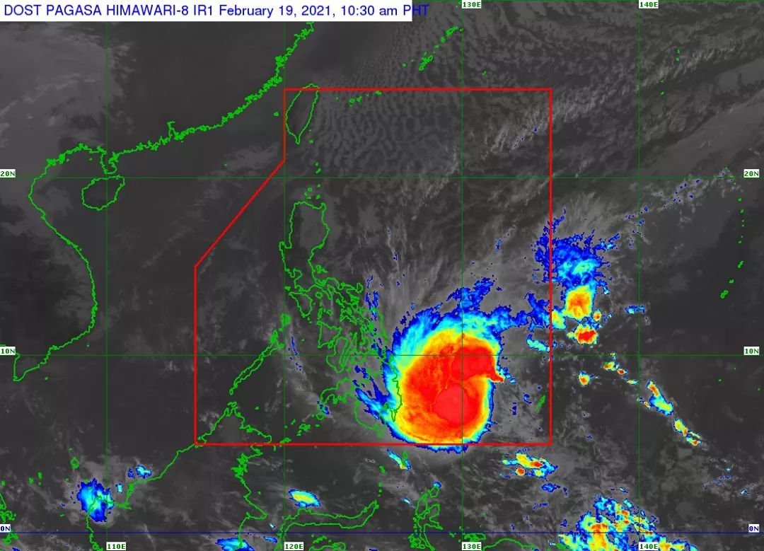
on Thursday placed more areas under Signal No. 3 as Typhoon ‘Ambo’ gained added strength, with forecasters warning of possible flooding and storm surge.
In its 8 a.m. severe weather bulletin, Pagasa raised Tropical Cyclone Wind Signal No. 3 in Sorsogon and the eastern section of Albay (Legazpi City, Manito, Daraga, Camalig, Jovellar, Santo Domingo, Bacacay, Rapu-Rapu).
Pagasa placed Northern Samar and the northern portion of Eastern Samar (Jipapad, Arteche, Maslog, Dolores, Oras, San Policarpio, Can-avid, Taft, Sulat, San Julian, Borongan City),and the northern portion of Samar (Calbayog City,Sta. Margarita,Gandara,Pagsanghan,San Jorge,Matuguinao,San Jose de Buan) under the same signal.
Heavy to intense with at times torrential rains as well as destructive winds will prevail over Samar, Eastern Samar and Northern Samar, while moderate to heavy with at times intense rains over Sorsogon, Albay, Catanduanes, Masbate, and the rest of Eastern Visayas, Pagasa said.
Flooding may be experienced over the coastal areas of Northern Samar, Eastern Samar, Samar, Sorsogon, Albay, Catanduanes, Camarines Sur, Camarines Norte, Quezon, and Aurora due to a possible storm surge of 1 to 3 meters within 48 hours, PAGASA warned.
Ambo is seen to make landfall in Northern Samar or Eastern Samar either this afternoon or tonight before heading to Sorsogon.
It was last located at 185 kilometers east of Catarman, Northern Samar, packing winds of 155 kilometers per hour near the center and gustiness of up to 190 kph.

Areas placed under TCWS No. 3 (Winds of greater than 121 kph up to 170 kph may be experienced in at least 18 hours)
– Northern Samar
– northern portion of Eastern Samar
Jipapad
Arteche
Maslog
Dolores
Oras
San Policarpio
Can-avid
Taft
– northern portion of Samar
Calbayog City
Sta. Margarita
Gandara
Pagsanghan
San Jorge
Matuguinao
San Jose de Buan
TCWS No. 2, which means winds of greater than 61 kph and up to 120 kph may be expected in at least 24 hours, is also raised over the following areas:
– Catanduanes
– eastern portion of Camarines Sur
Siruma
Tinambac
Goa
Lagonoy
San Jose,
Garchitorena,
Presentacion,
Caramoan,
Calabanga,
Bombon
Magarao
Canaman
Camaligan
Gainza
Pamplona
Naga City
Milaor
San Fernando
Minalabac
Pili
Ocampo
Tigaon
Bula
Baao
Sagñay
Iriga City
Buhi
Nabua
Balatan
Bato
– Ticao Islands
San Pascual
Claveria
Monreal
San Jacinto
San Fernando
Batuan
Aroroy
Baleno
Masbate City
Mobo
Uson
Dimasalang
Palanas
Cataingan
Pio V. Corpuz
– central part of Samar
Tarangnan
Catbalogan City
Jiabong
Motiong
Paranas
San Sebastian
Hinabangan
Tagapul-an
Almagro
Sto. Niño
– central part of Eastern Samar
Sulat
San Julian
Borongan City
Maydolong
Meanwhile, TCWS No. 1, which means winds of 30 to 60 kph may be expected in at least 36 hours or intermittent rains may be expected within 36 hours, is raised over the following areas:
– Cavite
– Laguna
– Batangas
– Rizal
– Quezon
– Marinduque
– eastern portion of Romblon
Banton
Corcuera
Romblon
Magdiwang
Cajidiocan
San Fernando
– Biliran
– the rest of Samar
– the rest of Eastern Samar,
– northern portion of Leyte
Calubian
San Isidro
Tabango
Villaba
Leyte
Kananga
Capoocan
Carigara
Barugo
San Miguel
Babatngon
Tunga
Jaro
Alangalang
Sta. Fe
Tacloban City
Palo
Pastrana
Dagami
Tabontabon
Tanauan
Tolosa